Latest changes on emta.com
Public transport networks
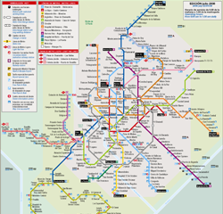
Description of the network: The public transport system for the Madrid region is a complex inter-modal system, consisting of various modes of transport: city and suburban buses, metro, light rail and suburban rail services. Two large subsystems can be detected: • The urban area of the city of Madrid: around 211 EMT city bus routes,
Identification of metropolitan area
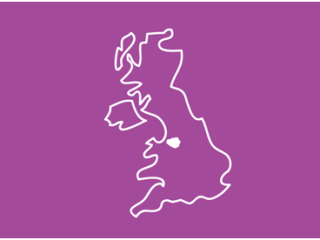
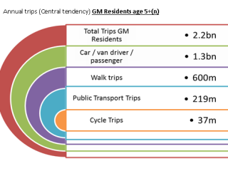
Greater Manchester: 2.7 million residents The heart of the north 10 local authorities across the political spectrum working together Longest-established combined authority in the UK – established in 2011. Centre of innovation, education, industry and culture Economic potential exceeds that of any other UK city region Home to: MediaCityUK Manchester, Salford and Manchester Metropolitan universities,
Public transport networks
What we do Transport for Greater Manchester is the delivery arm of an elected body: the Greater Manchester Combined Authority, a new strategic regional authority with functions relating to economic development and regeneration, regional planning, transport, skills and training, and air quality. Transport for Greater Manchester is responsible for implementing the policies and decisions of
Financing/Pricing data
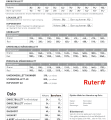
Key figures 2014 Ruter AS in MNOK (million norvegian kron) Operating revenues 3344 Sales of services OSLO 1608 Sales of services Akerhus 741 Oslo package 3 , Toll ring 715 Sales of services others 7 Government grants 53 Other income 149 Total incomes 6617 Net finance 37 Operating costs 6574 Supply and demand Metro
Identification of metropolitan area
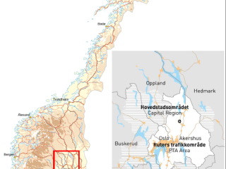
Description of the metropolitan area Oslo is the capital of Norway. Ruter’s service area, the Oslo and Akershus metropolitan region has 1.2 million inhabitants. In January 2015, the City of Oslo had 648 000 inhabitants and the surrounding Akershus county 585 000. Map of the region within the country
Public transport networks
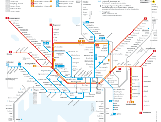
Public Transport System City Bus Network Oslo Bybuss 2015 Rail network Oslo 2015
Financing/Future developments
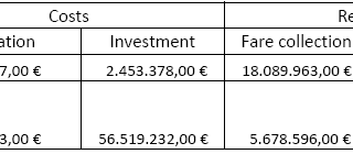
Fundings (2013) PT services are funded by fare collection and a transfer of funds from the regional government to cover the deficit, according to the following table: The funding of the CTM is the following: Future developments Currently, the CTM is working on the Public Transport Master Plan for Mallorca, which will design the new
Identification of metropolitan area
The area of influence of the CTM covers the whole island of Mallorca, the biggest island of the Balearic Archipelago. Its surface covers 3.640 km2 and it has a population of inhabitants 859.289 (2015). The capital city of Palma has a population of about 400.000. It must be highlighted that its main economic motor of
Public transport networks
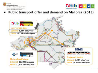
The network includes the following services: Interurban bus transport network, covering all municipalities of the island (known as TIB network), operated by private companies after a public tender. Commuter train from Palma to Inca, sa Pobla and Manacor, operated by the public transport operator Majorcan Railway Services (SFM). Palma metro, from Palma City Centre to
Financing/Pricing data
Budget 2017 IdFM operating budget amounted to €10,085m in 2017. However, fare revenues (that are decided by IdFM but are collected by the operators) have to be deducted (€ 3,814m) to that budget. Fares 2019 IdFM is responsible for the fare policy. The Ile-de-France region was divided into 5 concentric fare zones up to 31st
EMTA Members