Athens : Identification of the metropolitan area
Brief demographic and geographical data
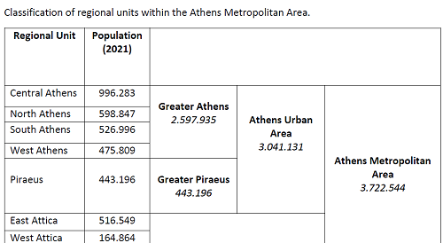
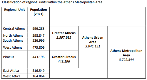
Athens is the capital city and the political, economic, maritime and cultural center of Greece. Athens is a Beta-status global city according to the Globalization and World Cities Research Network and is one of the biggest economic centers in Southeastern Europe. It also has a large financial sector, and its port Piraeus is the largest passenger port as well as the 5th largest container port in Europe. With a population close to four million, it is the largest urban conglomeration in Greece, and amongst the ten (10) largest cities in the European Union. The city of Athens, is also the capital of the Central Athens Regional Unit and of the region of Attica, spreading over an area of 39 km² with a population of 996.283 inhabitants.
The Athens Urban Area or extends beyond its administrative municipal city limits, with a population of 3,041,131 (in 2021) over an area of 412 km². Urban Area of the Capital today consists of 40 municipalities, 35 of which make up what was referred to as the former Athens Prefecture municipalities, located within 4 regional units (North Athens, West Athens, Central Athens, South Athens); and a further 5 municipalities, which make up the former Piraeus Prefecture municipalities, located within the regional unit of Piraeus.
Finally, the Athens Metropolitan Area spans 2,928.717 km² within the Attica region and includes a total of 58 densely populated municipalities, sprawling around the Municipality of Athens (the City Centre) in virtually all directions. The latter are organized in seven (7) regional units (North Athens, West Athens, Central Athens, South Athens, along with East Attica and West Attica), having reached a population of 3.722.544 based on the preliminary results of the 2021 census. Athens and Piraeus municipalities serve as the two metropolitan centers of the Athens Metropolitan Area.

Athens sprawls across the central plain of Attica that is often referred to as the Athens Basin or the Attica Basin. The basin is bounded by four large mountains: Mount Aigaleo to the west, Mount Parnitha to the north, Mount Pentelicus to the northeast and Mount Hymettus to the east. Beyond Mount Aegaleo lies the Thriasian plain, which forms an extension of the central plain to the west. The Saronic Gulf lies to the southwest. The Athens city coastline, extends from the major commercial port of Piraeus to the southernmost suburb of Varkiza for some 25 km. Mount Parnitha is the tallest of the four mountains (1,413 m) and has been declared a national park. The Cephissus river, the Ilisos and the Eridanos stream are the historical rivers of Athens.
The growth of the decade 2000-2009 in the region can be partly attributed to significant infrastructure investments made for the 2004 Olympic Games, the influx of the Structural Funds, but also to indigenous growth based mainly on consumption and at a lesser extent on investments triggered by low interest rates after the accession to the Eurozone. During that period, infrastructure projects to upgrade the transportation service level have been implemented, such as the development of the metro network, tram network and suburban railway, the development of Attiki Odos (the major peri-urban highway) as well as the construction of the new Athens international airport. The population and the densities of the municipalities of the Regional Unity Attica are presented in this Table.