How do I get from A to B? When is the next bus or the next train arriving respectively departing? Are there any delays or road works on the route? How do I get in time to my appointment?
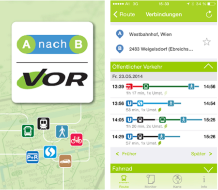
Answers to these and more questions are provided live via mobile phone since 1st June. To mark the 30th anniversary the Public Transport Authority Eastern Region (VOR), the new AnachB | VOR app offers on smartphones a multimodal route planner for Vienna, Lower Austria and Burgenland – and all of Austria!
The new app offers customers routes for public transport, cycling, walking on foot as well as combined mobility. Based on the same database, current networks, integration of traffic and parking search time, a realistic travel time comparison is possible for all means of transport. Over 600 park & ride facilities, 450 bike rental stations and over 1,000 stations and parking spaces are integrated for an optimal integration of different transportions throughout Austria.
AnachB | VOR app always uses the latest services of the Traffic Information Austria (VAO), including traffic reports (road works, traffic jams, etc.), the current traffic situation and delays or failures in the field of public transport can be displayed as well as the utilization of rental bike sites (including the number of free bikes and boxes).
The route planner finds not only the best way, but also offers practical additional functions: personal places of departure and routes can be saved as favorites. Moreover: route informations can also be recorded in the calendar on the mobile phone or sent by sms, email or on twitter. Public transport routes in Vienna, Lower Austria, Burgenland and Tyrol are also displayed with the tariff information of the respective transport authority.
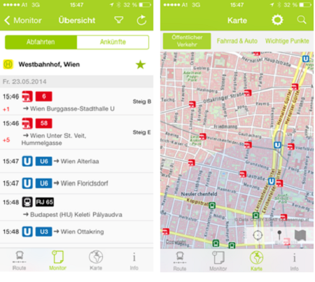
The app also provides a geographical map, which allows, among other things, address-accurate routing or selecting an arbitrary point using the “pin”. In the map view can be routed with tap faded stops or important points and these are set as start or destination point. The availability search – mobility radar – shows at a glance the accessibility of public transportations within a radius of max. 20 minutes from any point. An easy to read monitor rounds off the top offer of the new app: Here are all departures and arrivals displayed for each stop.
The new AnachB |VOR app is available for free for Android and iOS!
Contact: Jürgen Pogald